![](/images/other/stat-length.png)
![Tour Wandern San Cristóbal de La Laguna - Cruz del Carmen al Mar Bajamar - Photo](https://media.geolcdn.com/t/1900/400/ext.pjpeg?maxdim=2&url=https%3A%2F%2Fservices.sitytrail.com%2FGeolivesWS%2FDownloadMedia.ashx%3FTrailID%3D908007%26Media%3Dfix__20180218155348.jpg)
Cruz del Carmen al Mar Bajamar
TENERIFE
Benutzer
![Länge](/images/other/stat-length.png)
Länge
11,4 km
![Maximale Höhe](https://static1.geolcdn.com/siteimages/upload/files/1508320355ic_sort_altitude_max_24dp.png)
Maximale Höhe
955 m
![Positive Höhendifferenz](https://static1.geolcdn.com/siteimages/upload/files/1508320355ic_sort_den_pos_24dp.png)
Positive Höhendifferenz
80 m
![Km-Effort](/images/other/stat-length.png)
Km-Effort
15,6 km
![Min. Höhe](https://static1.geolcdn.com/siteimages/upload/files/1508320355ic_sort_altitude_min_24dp.png)
Min. Höhe
12 m
![Negative Höhendifferenz](https://static1.geolcdn.com/siteimages/upload/files/1508320355ic_sort_den_neg_24dp.png)
Negative Höhendifferenz
1015 m
![Boucle](https://static1.geolcdn.com/siteimages/upload/files/16400158638029165_repeat_loop_refresh_sync_direction_icon.png)
Boucle
Nein
Erstellungsdatum :
2018-04-17 19:20:11.212
Letzte Änderung :
2018-04-17 19:20:11.212
![Wandern](https://static1.geolcdn.com/sitytour/trail-icons/101.png)
3h04
Schwierigkeit : Einfach
![Scannen Sie diesen QR-Code, um die Tour in der SityTrail-Anwendung zu öffnen](https://capi.geolives.com/qq0zvz2zws4bq2lad0pu/sitytour/trails/908007/qr.png?size=200)
Kostenlosegpshiking-Anwendung
Über SityTrail
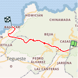
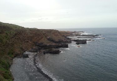
Tour Wandern von 11,4 km verfügbar auf Kanarische Inseln, Santa Cruz de Tenerife, San Cristóbal de La Laguna. Diese Tour wird von TENERIFE vorgeschlagen.
Beschreibung
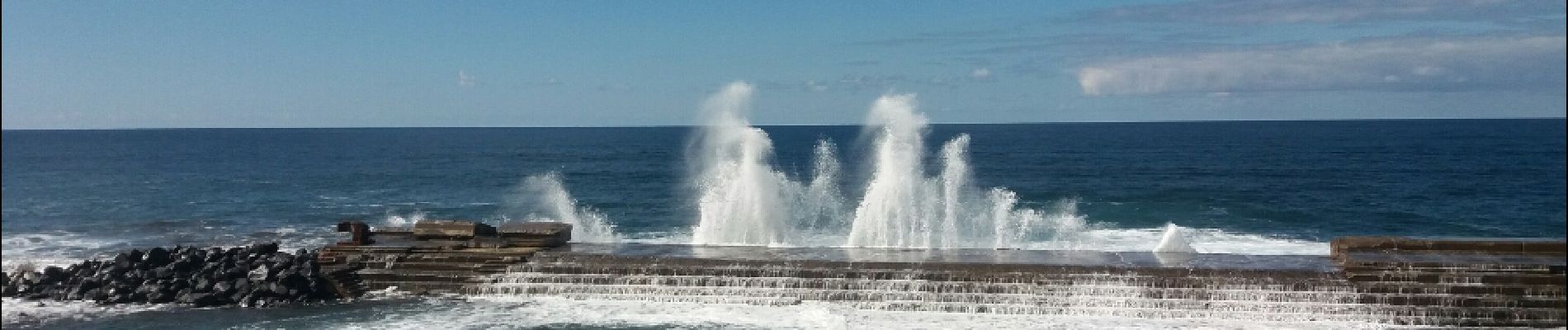
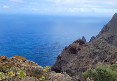
une longue descente facile mais monotone au début. Qqs passages pentus ensuite. Joli spectacle des vagues au bord de la mer à Bajamar .
Ort
Land:
Spain
Region :
Kanarische Inseln
Abteilung/Provinz :
Santa Cruz de Tenerife
Kommune :
San Cristóbal de La Laguna
Standort:
Unknown
Gehen Sie:(Dec)
Gehen Sie:(UTM)
374734 ; 3156748 (28R) N.
Kommentare
Touren in der Umgebung
![Tour Wandern San Cristóbal de La Laguna - Massif de l'Anaga El Batan Chinamada - Photo](https://media.geolcdn.com/t/375/260/bf287400-cf63-4351-bbc9-dbe9aba0fa64.jpg&format=jpg&maxdim=2)
![Wandern Wandern](https://static1.geolcdn.com/sitytour/trail-icons/101.png)
Massif de l'Anaga El Batan Chinamada
Wandern
Sehr schwierig
San Cristóbal de La Laguna,
Kanarische Inseln,
Santa Cruz de Tenerife,
Spain
![](/images/other/stat-length.png)
10,8 km | 21 km-effort
4h 45min
![](https://static1.geolcdn.com/siteimages/upload/files/16400158638029165_repeat_loop_refresh_sync_direction_icon.png)
Ja
![Tour Zu Fuß Tegueste - El bosque de los enigmas - Photo](https://media.geolcdn.com/t/375/260/1a03fed7-fb28-4a0e-9d0f-13adda6bed3b.jpeg&format=jpg&maxdim=2)
![Zu Fuß Zu Fuß](https://static1.geolcdn.com/sitytour/trail-icons/100.png)
El bosque de los enigmas
Zu Fuß
Einfach
(1)
Tegueste,
Kanarische Inseln,
Santa Cruz de Tenerife,
Spain
![](/images/other/stat-length.png)
4,5 km | 6,7 km-effort
1h 31min
![](https://static1.geolcdn.com/siteimages/upload/files/16400158638029165_repeat_loop_refresh_sync_direction_icon.png)
Ja
![Tour Zu Fuß San Cristóbal de La Laguna - Camino de Candelaria de Tegueste - Photo](https://media.geolcdn.com/t/375/260/be0e3d77-69cd-4aea-addd-378ac79d031e.jpeg&format=jpg&maxdim=2)
![Zu Fuß Zu Fuß](https://static1.geolcdn.com/sitytour/trail-icons/100.png)
Camino de Candelaria de Tegueste
Zu Fuß
Einfach
San Cristóbal de La Laguna,
Kanarische Inseln,
Santa Cruz de Tenerife,
Spain
![](/images/other/stat-length.png)
5 km | 7,5 km-effort
1h 41min
![](https://static1.geolcdn.com/siteimages/upload/files/16400158638029165_repeat_loop_refresh_sync_direction_icon.png)
Nein
![Tour Wandern San Cristóbal de La Laguna - Punta del Hidalgo - Chinamada - Photo](https://media.geolcdn.com/t/375/260/2c9fb02f-c984-4854-86fb-fc5721d63a53.jpg&format=jpg&maxdim=2)
![Wandern Wandern](https://static1.geolcdn.com/sitytour/trail-icons/101.png)
Punta del Hidalgo - Chinamada
Wandern
Medium
San Cristóbal de La Laguna,
Kanarische Inseln,
Santa Cruz de Tenerife,
Spain
![](/images/other/stat-length.png)
10,9 km | 20 km-effort
3h 30min
![](https://static1.geolcdn.com/siteimages/upload/files/16400158638029165_repeat_loop_refresh_sync_direction_icon.png)
Ja
![Tour Wandern San Cristóbal de La Laguna - Las Carbonaras Chimada AR - Photo](https://media.geolcdn.com/t/375/260/b1c626c3-3510-4ce3-890e-282b82838da6.jpg&format=jpg&maxdim=2)
![Wandern Wandern](https://static1.geolcdn.com/sitytour/trail-icons/101.png)
Las Carbonaras Chimada AR
Wandern
Einfach
(1)
San Cristóbal de La Laguna,
Kanarische Inseln,
Santa Cruz de Tenerife,
Spain
![](/images/other/stat-length.png)
5,7 km | 8,8 km-effort
1h 35min
![](https://static1.geolcdn.com/siteimages/upload/files/16400158638029165_repeat_loop_refresh_sync_direction_icon.png)
Ja
![Tour Wandern Santa Cruz de Tenerife - Afur - Taganana - Photo](https://media.geolcdn.com/t/375/260/3c968652-f4ba-48a3-a0da-108b9b20f163.jpg&format=jpg&maxdim=2)
![Wandern Wandern](https://static1.geolcdn.com/sitytour/trail-icons/101.png)
Afur - Taganana
Wandern
Medium
Santa Cruz de Tenerife,
Kanarische Inseln,
Santa Cruz de Tenerife,
Spain
![](/images/other/stat-length.png)
12,3 km | 22 km-effort
4h 53min
![](https://static1.geolcdn.com/siteimages/upload/files/16400158638029165_repeat_loop_refresh_sync_direction_icon.png)
Ja
![Zu Fuß Zu Fuß](https://static1.geolcdn.com/sitytour/trail-icons/100.png)
Pico del Ingles circulaire
Zu Fuß
Medium
Santa Cruz de Tenerife,
Kanarische Inseln,
Santa Cruz de Tenerife,
Spain
![](/images/other/stat-length.png)
9,2 km | 17 km-effort
4h 0min
![](https://static1.geolcdn.com/siteimages/upload/files/16400158638029165_repeat_loop_refresh_sync_direction_icon.png)
Ja
![Tour Wandern San Cristóbal de La Laguna - forêt primaire de l'Anaga - Photo](https://media.geolcdn.com/t/375/260/ext.jpg?maxdim=2&url=https%3A%2F%2Fservices.sitytrail.com%2FGeolivesWS%2FDownloadMedia.ashx%3FTrailID%3D422872%26Media%3D20150511145711.jpg)
![Wandern Wandern](https://static1.geolcdn.com/sitytour/trail-icons/101.png)
forêt primaire de l'Anaga
Wandern
Einfach
(2)
San Cristóbal de La Laguna,
Kanarische Inseln,
Santa Cruz de Tenerife,
Spain
![](/images/other/stat-length.png)
9,4 km | 13,4 km-effort
3h 23min
![](https://static1.geolcdn.com/siteimages/upload/files/16400158638029165_repeat_loop_refresh_sync_direction_icon.png)
Ja
![Tour Wandern San Cristóbal de La Laguna - Punta de Hidalgo - Batan de Abajo - Photo](https://media.geolcdn.com/t/375/260/ext.jpg?maxdim=2&url=https%3A%2F%2Fservices.sitytrail.com%2FGeolivesWS%2FDownloadMedia.ashx%3FTrailID%3D384279%26Media%3Dfix__20150101180529.jpg)
![Wandern Wandern](https://static1.geolcdn.com/sitytour/trail-icons/101.png)
Punta de Hidalgo - Batan de Abajo
Wandern
Sehr leicht
San Cristóbal de La Laguna,
Kanarische Inseln,
Santa Cruz de Tenerife,
Spain
![](/images/other/stat-length.png)
14,4 km | 26 km-effort
5h 49min
![](https://static1.geolcdn.com/siteimages/upload/files/16400158638029165_repeat_loop_refresh_sync_direction_icon.png)
Ja